- English
Languages:
This site is created using Wikimapia data. Wikimapia is an open-content collaborative map project contributed by volunteers around the world. It contains information about 32729161 places and counting.
Learn more about Wikimapia and cityguides.
Machilipatnam
Tehsil Machilipatnam, District Krishna (Machilpatnam), Andhra Pradesh, Bharat
Machilipatnam is the District Head quarters of Krishna dt. There are 50 Mandals under Krishna dt. and the list is :1 Jaggayyapeta 2 Vatsavai 3 Penuganchiprolu 4 Nandigama 5 Chandarlapadu 6 Kanchika Cherla 7 Veerullapadu 8 Ibrahimpatnam 9 G Konduru 10 Mylavaram 11 A Konduru 12 Gampalagudem 13 Gannavaram 14 Vissannapet 15 Reddigudem 16 Vijayawada Rural 17 Vijayawada Urban 18 Penamaluru 19 Thotlavalluru 20 Kankipadu 21Tiruvuru 22 Agiripalle, 23 Nuzvid 24 Chatrai 25 Musunuru 26 Bapulapadu 27 Unguturu 28 Vuyyuru 29 Pamidimukkala 30 Movva 31 Ghantasala 32 Challapalli 33 Mopidevi 34 Avanigadda 35 Nagayalanka 36 Koduru 37 Machilipatnam 38 Gudur 39 Pamarru 40 Pedaparupudi 41 Nandivada 42 Gudivada 43 Gudlavalleru 44 Pedana 45 Bantumilli 46 Mudinapalli 47 Mandavalli 48 Kaikalur 49 Kalidindi 50 Kruthivennu
Also, Machalipatnam is a Mandal Head Quarter(Mandal code37) in Krishna Dt. There are 28 villages under this mandal and the list is :1 pedapatnam, 2 kanuru, 3 thallapalem, 4 gokavaram, 5 manginapudi, 6 kothapudi, 7 buddalapalem, 8 borrapothupalem, 9 hussainpalem, 10 arisepalle, 11 machavaram (r), 12 pothapalle, 13 potlapalem, 14 tavisipudi, 15 gopuvanipalem, 16 chilakalapudi (r), 17 kara agraharam, 18 bandar (machilipatnam), 19 sultannagaram gollapale, 20 rudravaram, 21 gundupalem, 22 chinnapuram, 23 nelakurru, 24 bhogireddipalle, 25 peda yadara, 26 kona, 27 polatitippa, 28 palletummalapalem
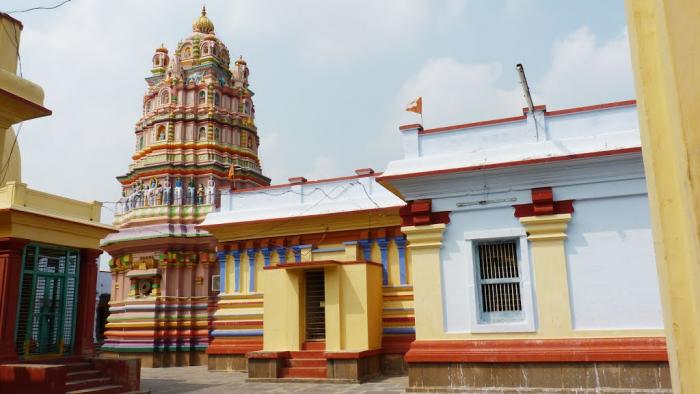
Machilipatnam is a city and a special grade municipality in the Krishna district, Andhra Pradesh, India. The town has existed since the 3rd century BCE (Satavahana period) when, according to Ptolemy, it was known as Maisolos. The Periplus of the Erythraean Sea calls it Masalia in the 1st century CE. The port is located on the southeastern, or Coromandel Coast, of India. Situated in the mouth of the River Krishna on the Bay of Bengal, the Masula port saw flourishing sea trade. It was a 17th century port for French, British and Dutch trade, then it was known as Masulipatam.
The port has a medium-size fishing harbour which can accommodate 350 fishing vessels and an active carpet-weaving industry. The other products from the town include rice, oilseeds and scientific instruments. This town is a railway terminus and an important educational centre.
The area is vulnerable to storm surges caused by the frequent cyclones in the Bay of Bengal. The 2004 Tsunami affected many fishing villages around Machilipatnam. The Government and NGOs are involved in rebuilding and reconstructing devastated villages.
Machilipatnam was a flourishing seaport on the east coast during the time of the Satavahanas. It was mentioned in the Periplus that a great quantity of muslins are made in Masalia. Finest muslins were exported from Masulipatam to Egypt, Rome, Athens and Arabia. The town retained its importance throughout the history and was the major port of Golkonda kingdom. In the 17th century CE, the port was a centre of French, British and Dutch trade. It is one of the earliest known British settlements in the Indian subcontinent and the British East India Company's first trading post on the Coromandel coast. An agency was established there in 1611 CE. During the Carnatic Wars, the British were temporarily expelled from the town, which was held by the French for some years. In 1759, the town and fort were captured by Colonel Forde, an achievement followed by the acquisition of the Northern Circars. In 1864 a great storm-wave swept over the entire town and is said to have destroyed 30,000 lives. A monument was erected by the then District collector of Masulipatam, Mr Thornhill, almost 3 km away from the inundated town in Robertson Square (nowadays familiar as Koneru centre)
The port is only a roadstead, where vessels anchor 5 m. out. A branch line from Vijayawada on the Southern Mahratta railway was opened in 1908. The port of Machilipatnam today is in need of modernization. It has not seen any ships in the last decade. In its heyday, the port used to handle exports of items weighing more than 2.7 lakh tonnes and imports of 37,000 tonnes. It used to export Iron Ore to Japan. In January 2006, the Government of Andhra Pradesh revealed plans to revive the Machilipatnam port at a cost of Rs. 1200 crores. It has allocated 6000 acres (24 km2) of land for the project
Wikipedia article: http://en.wikipedia.org/wiki/Machilipatnam
Tehsil Machilipatnam, District Krishna (Machilpatnam), Andhra Pradesh, Bharat
Machilipatnam is the District Head quarters of Krishna dt. There are 50 Mandals under Krishna dt. and the list is :1 Jaggayyapeta 2 Vatsavai 3 Penuganchiprolu 4 Nandigama 5 Chandarlapadu 6 Kanchika Cherla 7 Veerullapadu 8 Ibrahimpatnam 9 G Konduru 10 Mylavaram 11 A Konduru 12 Gampalagudem 13 Gannavaram 14 Vissannapet 15 Reddigudem 16 Vijayawada Rural 17 Vijayawada Urban 18 Penamaluru 19 Thotlavalluru 20 Kankipadu 21Tiruvuru 22 Agiripalle, 23 Nuzvid 24 Chatrai 25 Musunuru 26 Bapulapadu 27 Unguturu 28 Vuyyuru 29 Pamidimukkala 30 Movva 31 Ghantasala 32 Challapalli 33 Mopidevi 34 Avanigadda 35 Nagayalanka 36...
 Reduce description
Machilipatnam on the map.


Recent city comments: